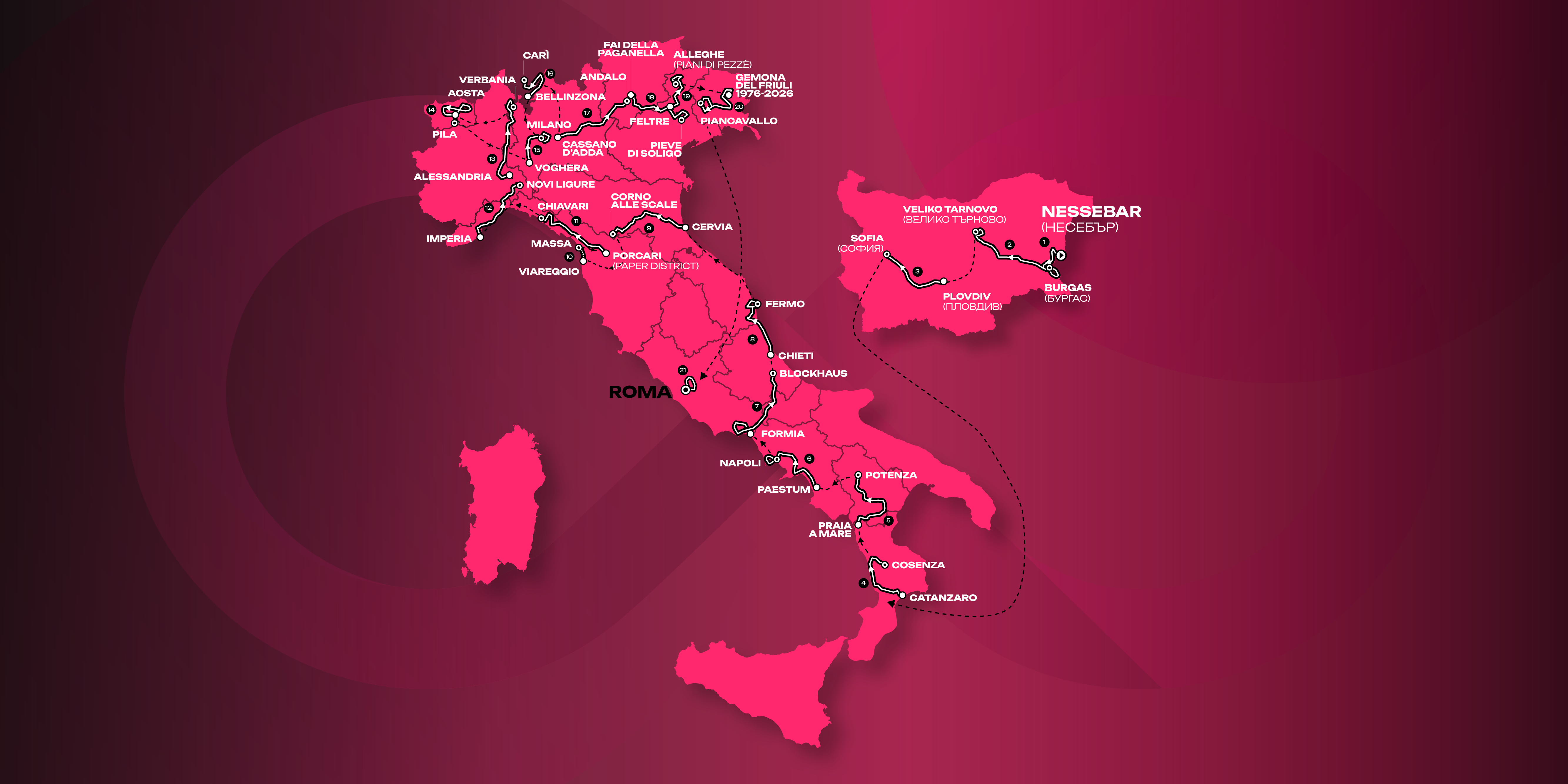


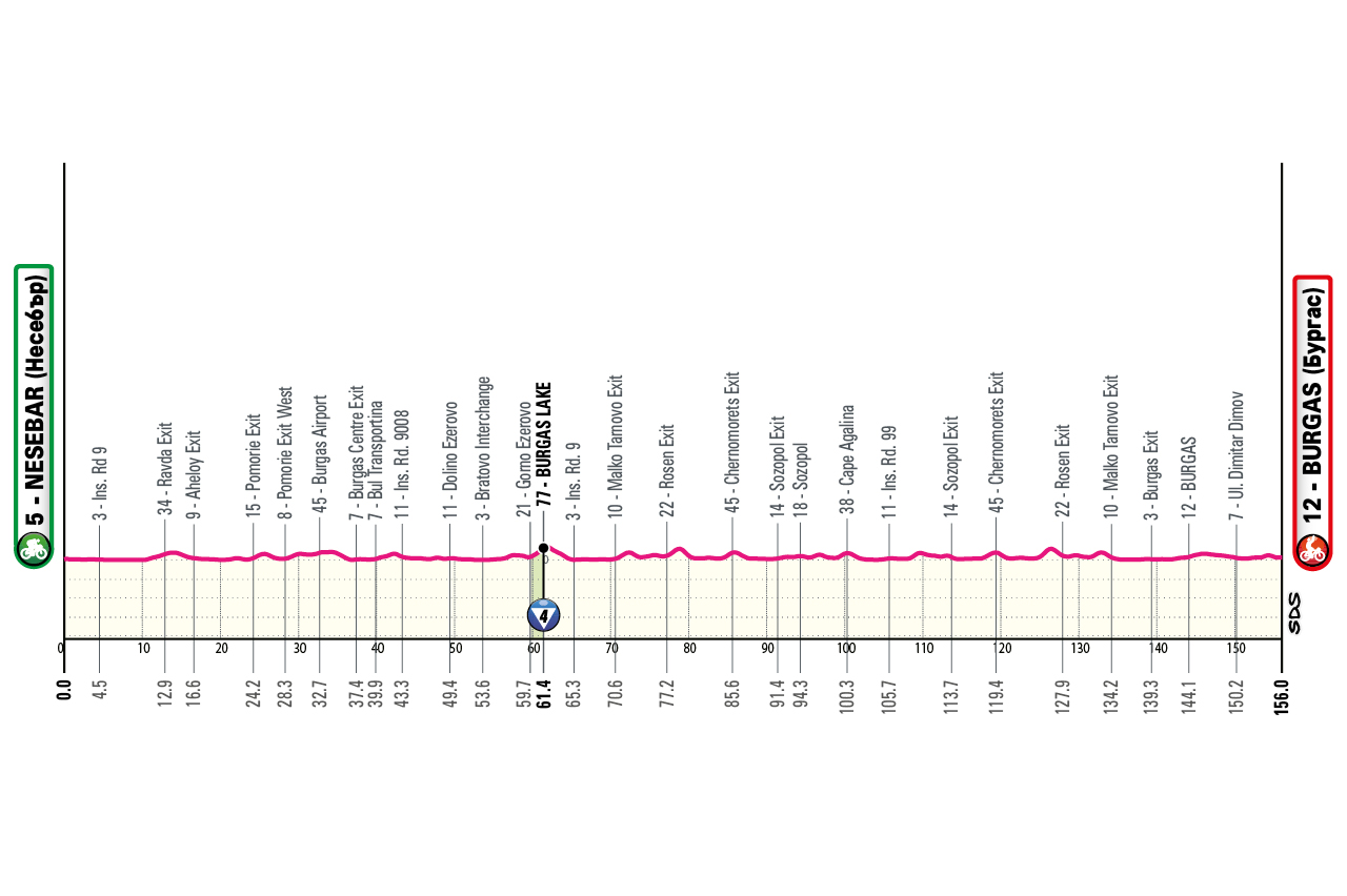
08/05/2026
profile
map

technical info
Flat stage. Start from historic Nessebar, a Greek colony founded in the 6th century BC. Finish in Burgas, a Black Sea resort town. First Maglia Rosa awarded in a sprint.
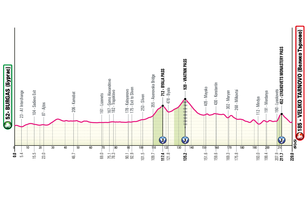
09/05/2026
profile
map

technical info
Long stage with climbs in the central section to cross Bulgaria’s main mountain chain. The finish features a sharp uphill kick just a few kilometres from Veliko Tarnovo: Lyaskovets Monastery climb (~3.5 km at 7.5%, with a long section in double-digit gradients).
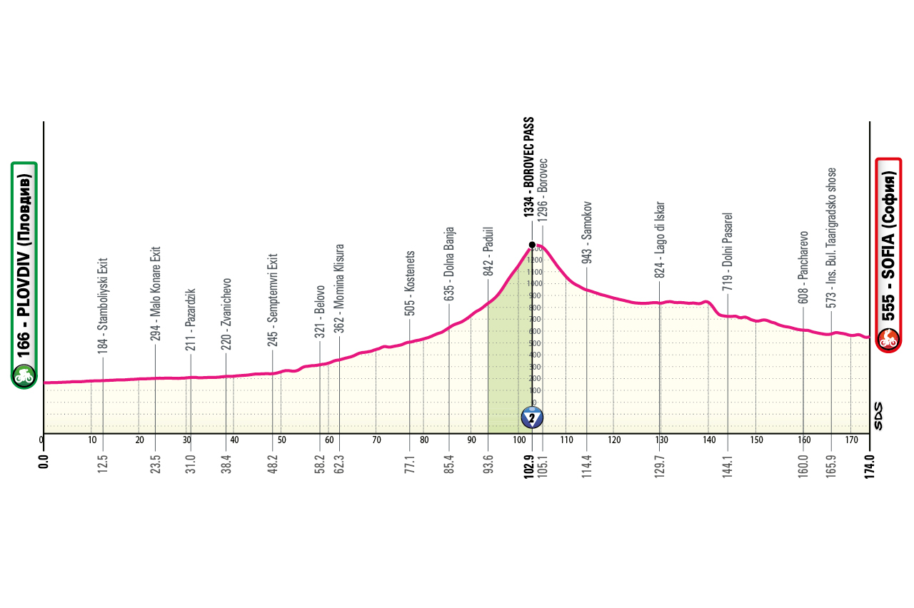
10/05/2026
profile
map

technical info
One long but steady intermediate climb (Borovets) before a likely sprint in Sofia.
12/05/2026
profile
map

technical info
Short stage after the transfer, with a likely sprint despite a long, easy mid-stage climb.
13/05/2026
profile
map

technical info
Rolling stage with many climbs and a punchy uphill finish. The route crosses the Pollino National Park. Finale similar -though not identical – to 2022 (Bouwman).
14/05/2026
profile
map

technical info
Likely sprint after an undulating middle section and a finishing circuit with several short climbs, the last very close to the finish.
15/05/2026
profile
map

technical info
First summit finish. Longest stage of the Giro at 246 km. Coastal run through Sperlonga and Gaeta, then into Abruzzo. Blockhaus climbed from Roccamorice, the hardest side: final 10 km consistently around, or above, 10%.
16/05/2026
profile
map

technical info
Rolling “Muri-style” stage similar to Tirreno Adriatico. Several steep walls, including Capodarco, site of the famous U23 race, then another wall to reach the town centre.
17/05/2026
profile
map

technical info
Flat start then increasingly rolling terrain into the Tuscan-Emilian Apennines, ending uphill at Corno alle Scale (Rifugio Cavone). Final climb alternates steep ramps with easier stretches.
19/05/2026
profile
map

technical info
Completely flat individual time trial, expected to be extremely fast (estimated 56–57 km/h). The first 10 km feature multiple curves around Viareggio and Torre del Lago Puccini; then a long, straight coastal section where top specialists may hit 60 km/h.
20/05/2026
profile
map

technical info
Rolling stage with a demanding second half through the Cinque Terre (Levanto). Steep final ramp just before the line.
21/05/2026
profile
map

technical info
Early climbs (Colle Giovo / Bric Berton) before entering the Po Valley. Likely sprint finish.
22/05/2026
profile
map

technical info
Flat stage with tricky final climbs: Bieno (5%) and Ungiasca (7% with long double-digit stretches). Finish by the lake.
23/05/2026
profile
map
technical info
Brutal stage with over 4,000 m of climbing. Riders traverse Aosta’s “balconies” and cover Saint-Barthélémy, Douas, Lin Noir, Verrogne, and Pila, climbed for the first time from the Gressan side (normally tackled downhill).
24/05/2026
profile
map

technical info
Completely flat stage featuring a final city circuit. Bunch sprint guaranteed.
26/05/2026
profile
map
technical info
Very short but high-altitude stage. Early circuit with two demanding climbs (Torre, Leontica) before a straight uphill finish in Carì.
27/05/2026
profile
map
technical info
Initially flat, then a sequence of short climbs to the finish. Short, partially closed loop near the end.
28/05/2026
profile
map
technical info
Gently undulating stage with continuous rollers. Neutral descent to km 0, then relentless ups and downs. At 9 km to go, the famous Muro di Ca’ del Poggio may be the key factor between a sprint and a selective finish.
29/05/2026
profile
map
technical info
Classic Dolomite tappone in climbing style but modern in length: 151 km with 5,000 m of elevation. Riders face Passo Duran, Passo Staulanza (via the steep Coi variant, up to 19%), Passo Giau from its hardest side (Cima Coppi, 2236 m), Passo Falzarego, then the final short climb (5 km at ~10%, peaks 15%).
30/05/2026
profile
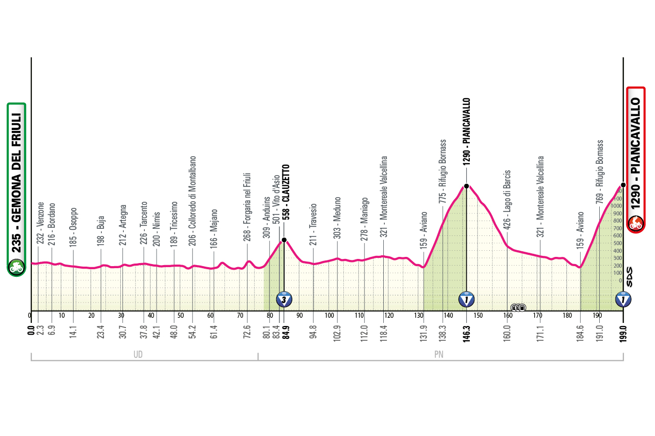
map
technical info
Rolling early terrain, then a double ascent of Piancavallo. The route crosses the epicentre of the 1976 Friuli earthquake (990 victims, tens of thousands displaced) before climbing Piancavallo twice, with a loop including Lago di Barcis. Pantani won here in 1998 before taking the Giro overall.
31/05/2026
profile
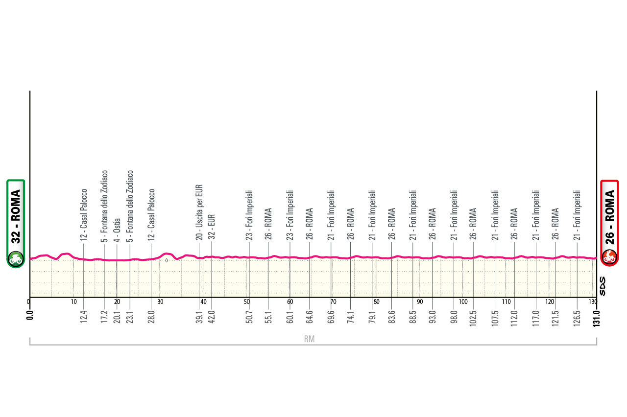
map

technical info
Final parade stage, essentially identical to recent years: an opening out-and-back run to Ostia, followed by several laps of the city-centre circuit.
Nessebar / Несебър – Burgas / Бургас
profile
map
technical info
Flat stage. Start from historic Nessebar, a Greek colony founded in the 6th century BC. Finish in Burgas, a Black Sea resort town. First Maglia Rosa awarded in a sprint.
Burgas / Бургас – Veliko Tarnovo / Велико Търново
profile
map
technical info
Long stage with climbs in the central section to cross Bulgaria’s main mountain chain. The finish features a sharp uphill kick just a few kilometres from Veliko Tarnovo: Lyaskovets Monastery climb (~3.5 km at 7.5%, with a long section in double-digit gradients).
Plovdiv / Пловдив – Sofia / София
profile
map
technical info
One long but steady intermediate climb (Borovets) before a likely sprint in Sofia.
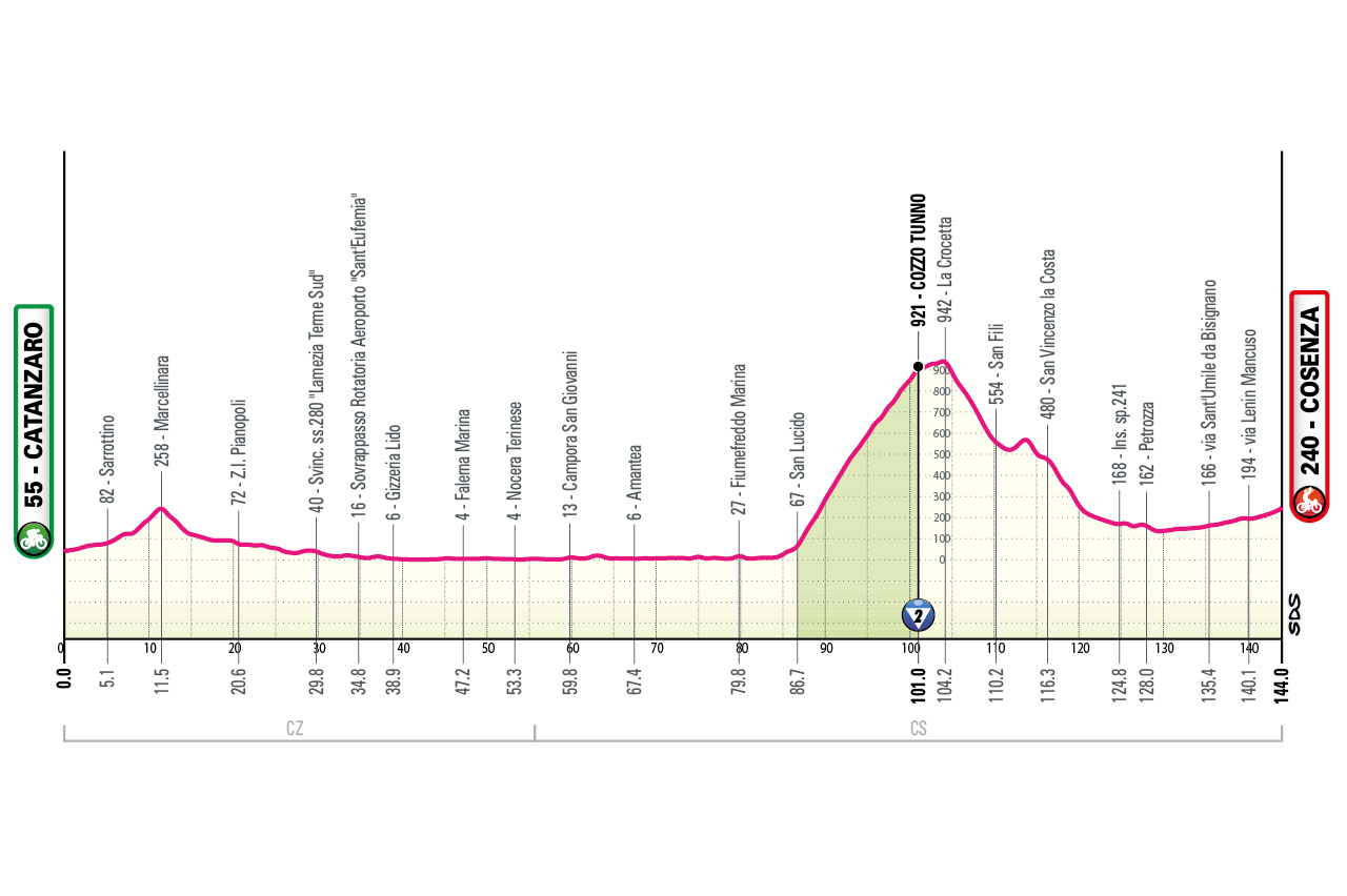
Catanzaro – Cosenza
profile
map
technical info
Short stage after the transfer, with a likely sprint despite a long, easy mid-stage climb.
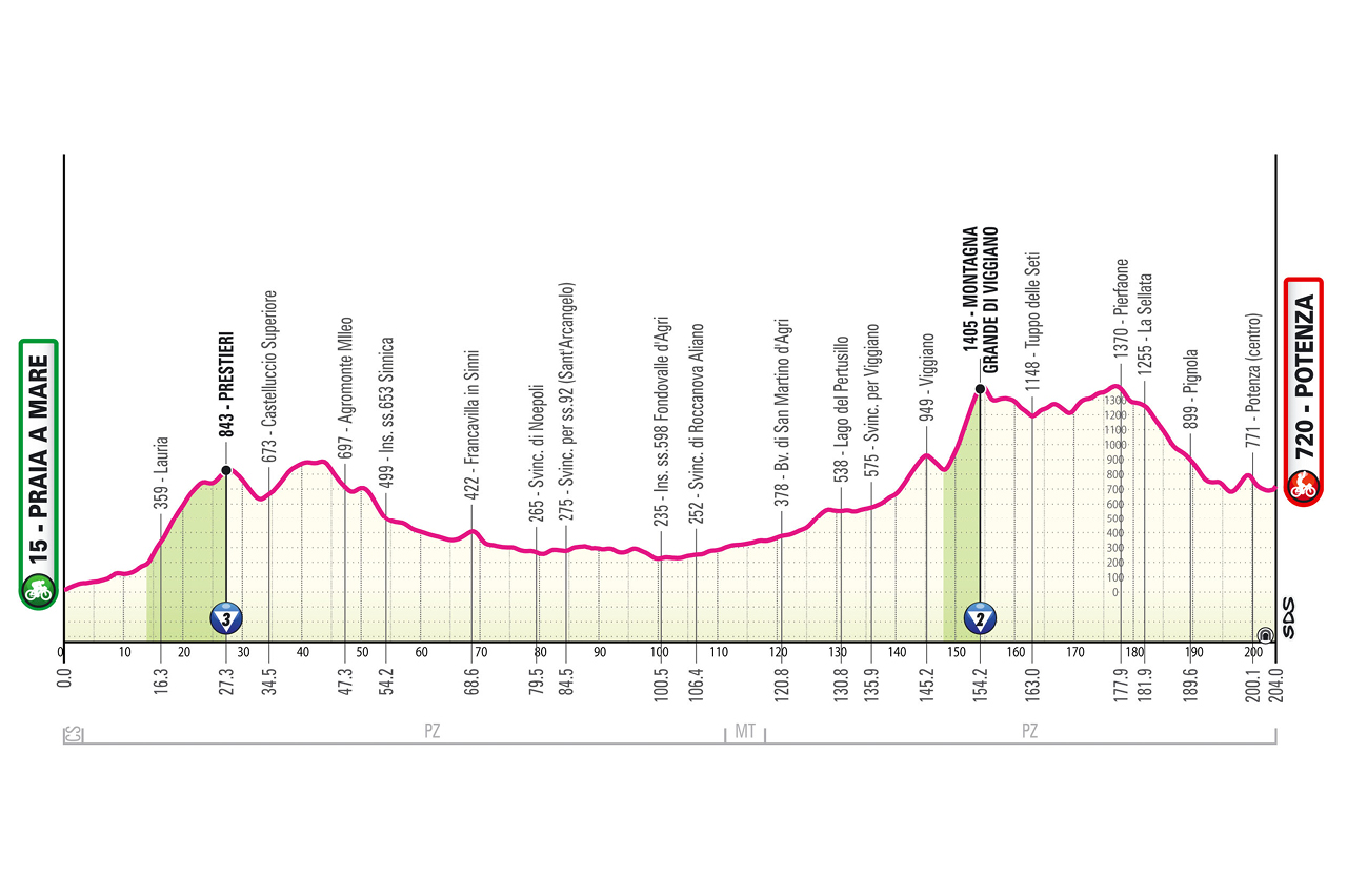
Praia a Mare – Potenza
profile
map
technical info
Rolling stage with many climbs and a punchy uphill finish. The route crosses the Pollino National Park. Finale similar -though not identical – to 2022 (Bouwman).
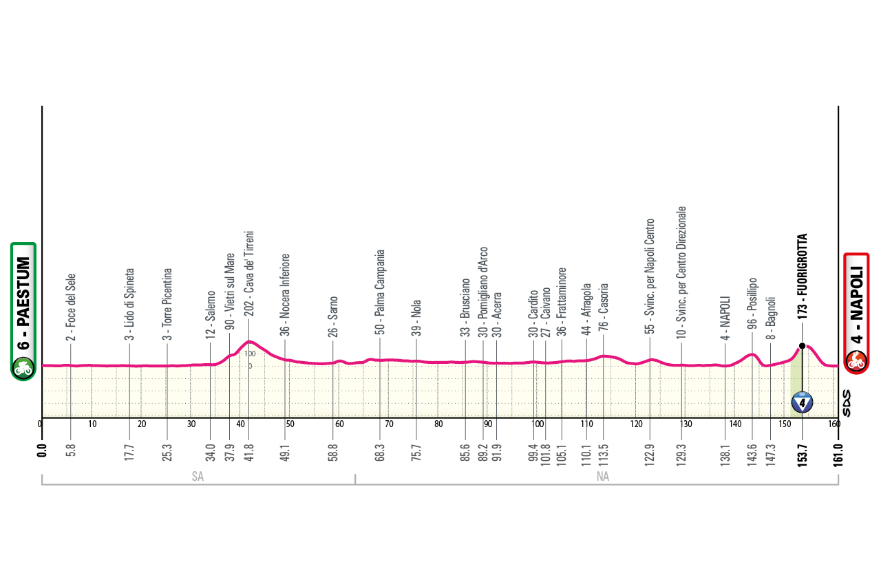
Paestum – Napoli
profile
map
technical info
Likely sprint after an undulating middle section and a finishing circuit with several short climbs, the last very close to the finish.
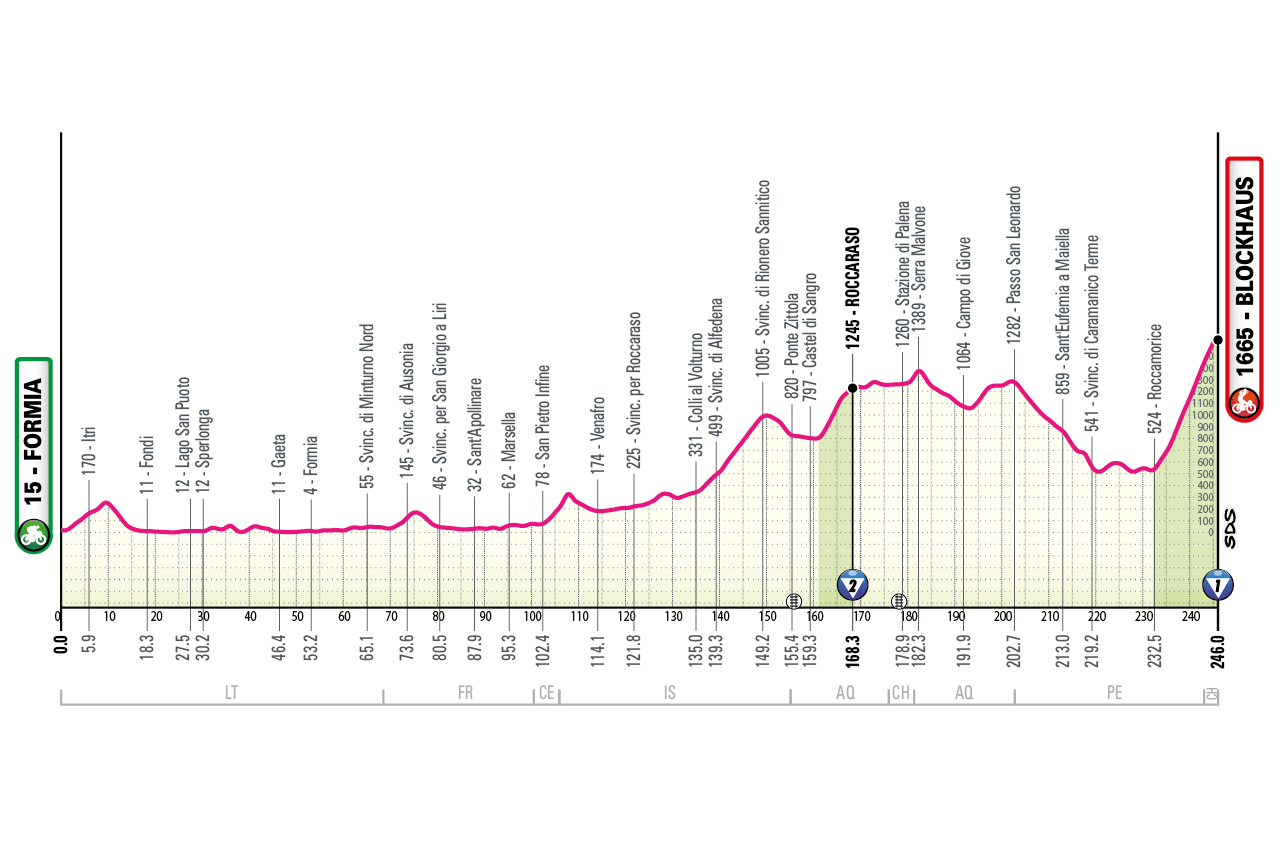
Formia – Blockhaus
profile
map
technical info
First summit finish. Longest stage of the Giro at 246 km. Coastal run through Sperlonga and Gaeta, then into Abruzzo. Blockhaus climbed from Roccamorice, the hardest side: final 10 km consistently around, or above, 10%.
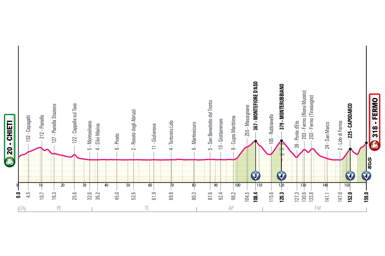
Chieti – Fermo
profile
map
technical info
Rolling “Muri-style” stage similar to Tirreno Adriatico. Several steep walls, including Capodarco, site of the famous U23 race, then another wall to reach the town centre.
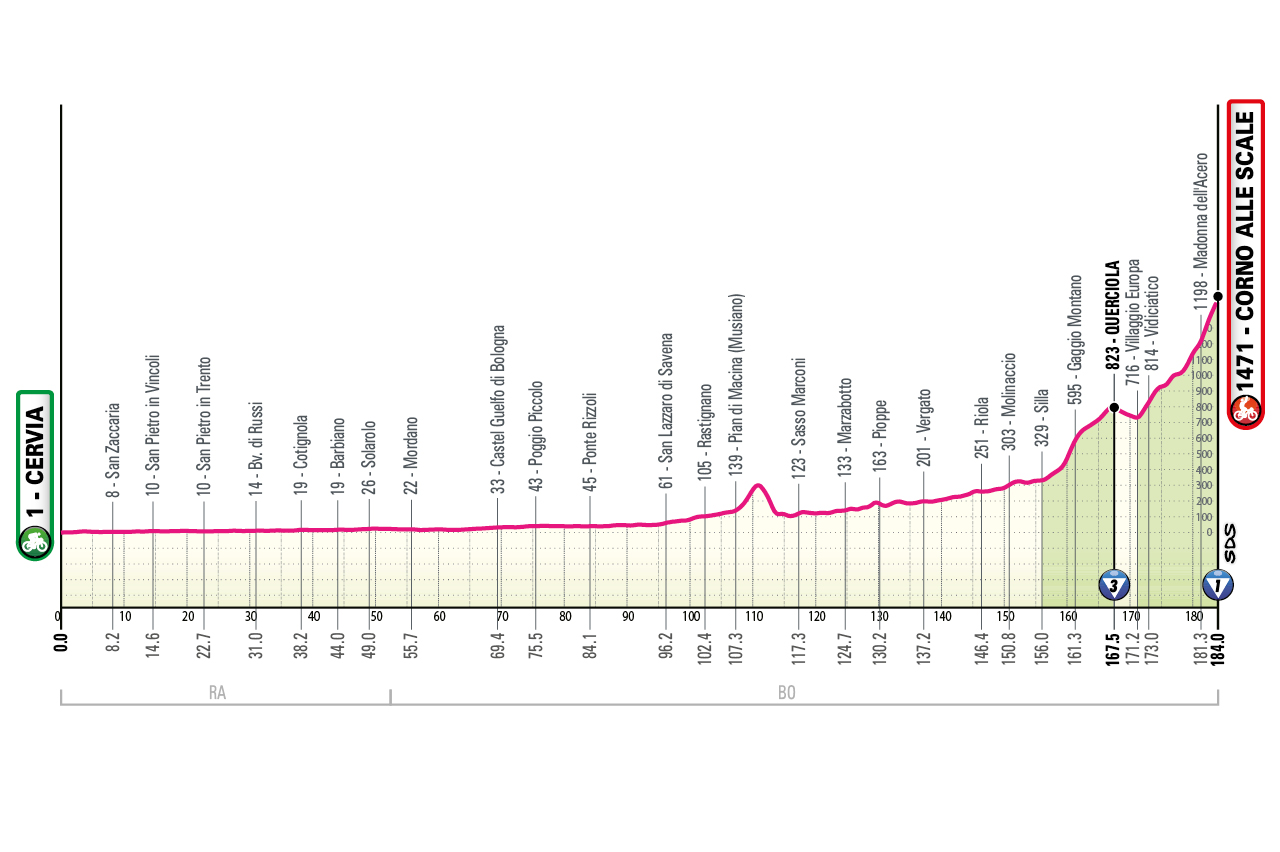
Cervia – Corno alle Scale
profile
map
technical info
Flat start then increasingly rolling terrain into the Tuscan-Emilian Apennines, ending uphill at Corno alle Scale (Rifugio Cavone). Final climb alternates steep ramps with easier stretches.
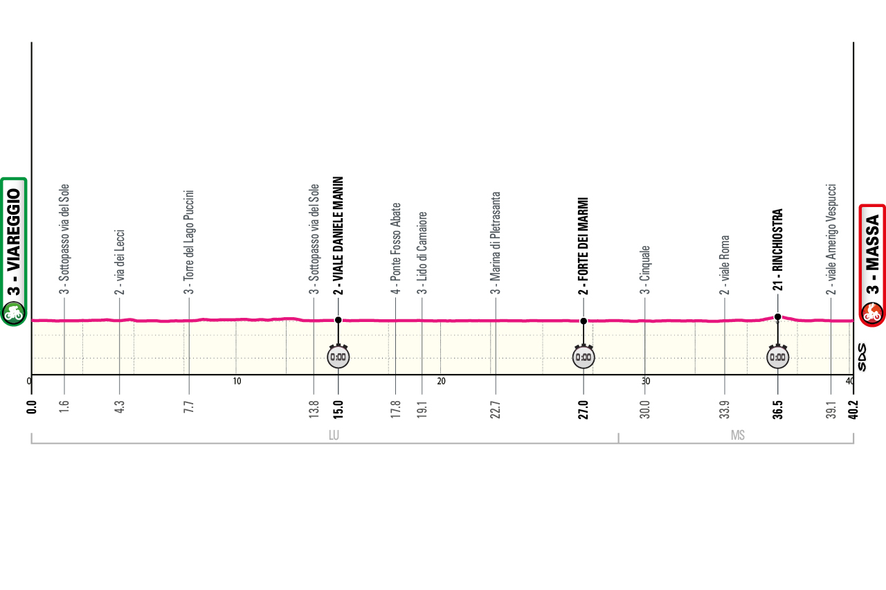
Viareggio – Massa TUDOR ITT
profile
map
technical info
Completely flat individual time trial, expected to be extremely fast (estimated 56–57 km/h). The first 10 km feature multiple curves around Viareggio and Torre del Lago Puccini; then a long, straight coastal section where top specialists may hit 60 km/h.
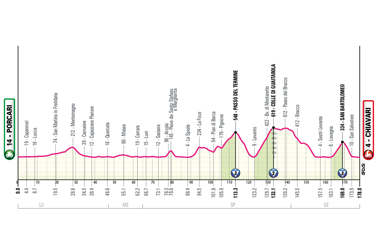
Porcari (Paper District) – Chiavari
profile
map
technical info
Rolling stage with a demanding second half through the Cinque Terre (Levanto). Steep final ramp just before the line.
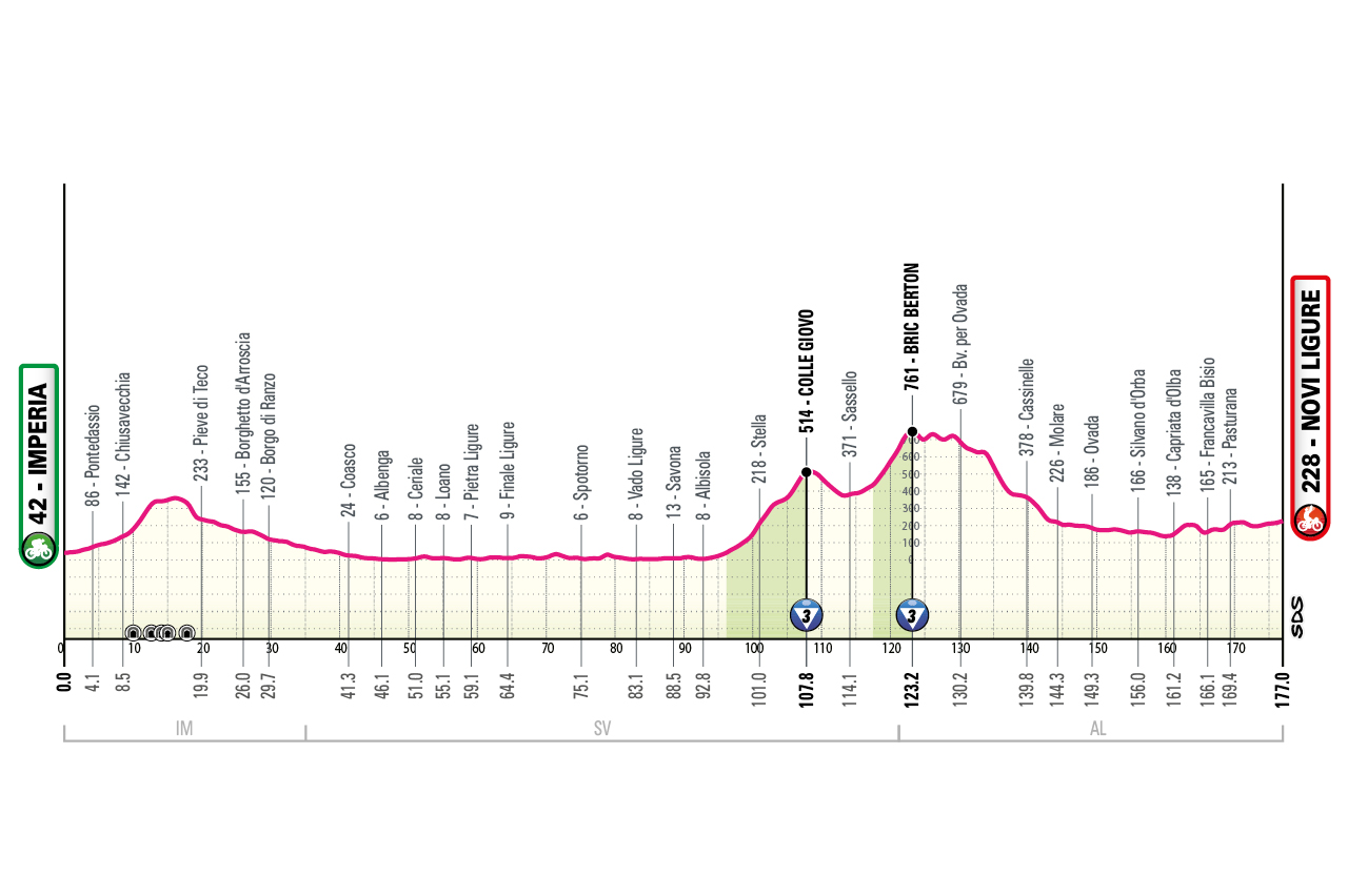
Imperia – Novi Ligure
profile
map
technical info
Early climbs (Colle Giovo / Bric Berton) before entering the Po Valley. Likely sprint finish.
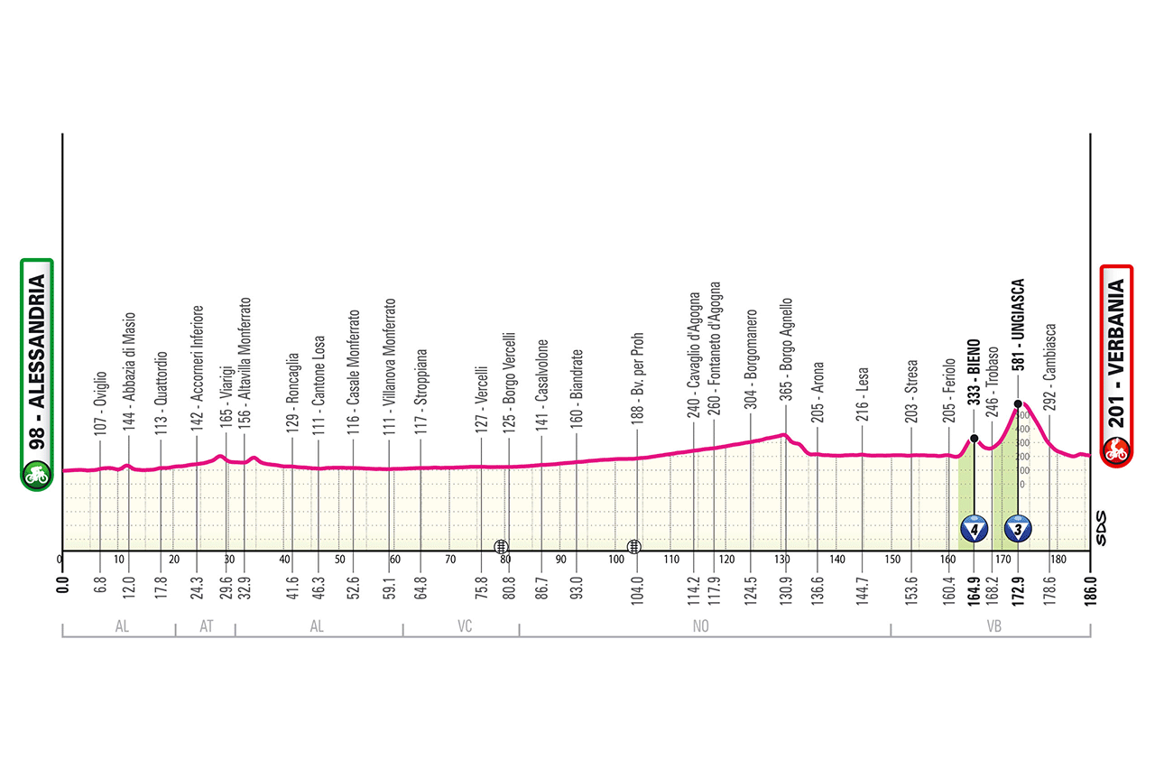
Alessandria – Verbania
profile
map
technical info
Flat stage with tricky final climbs: Bieno (5%) and Ungiasca (7% with long double-digit stretches). Finish by the lake.
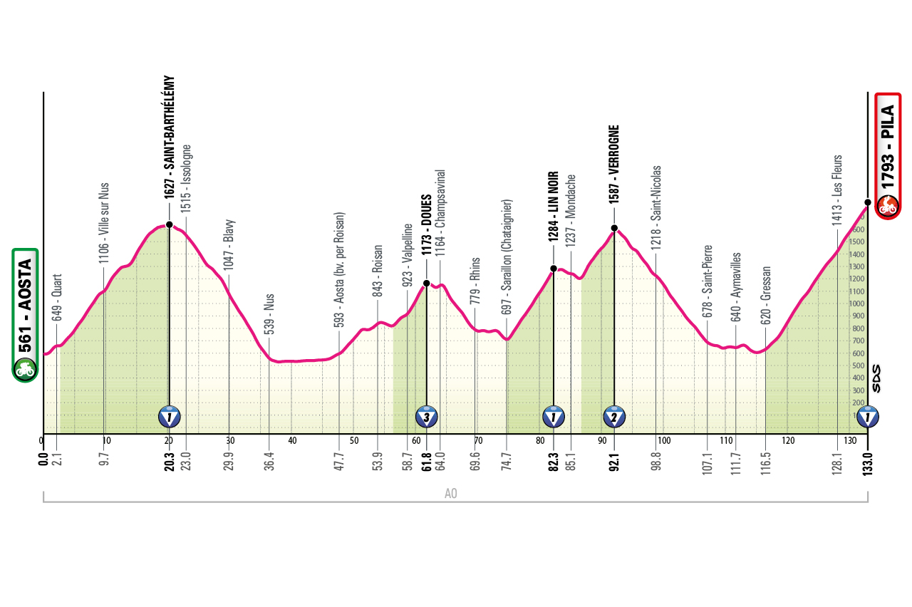
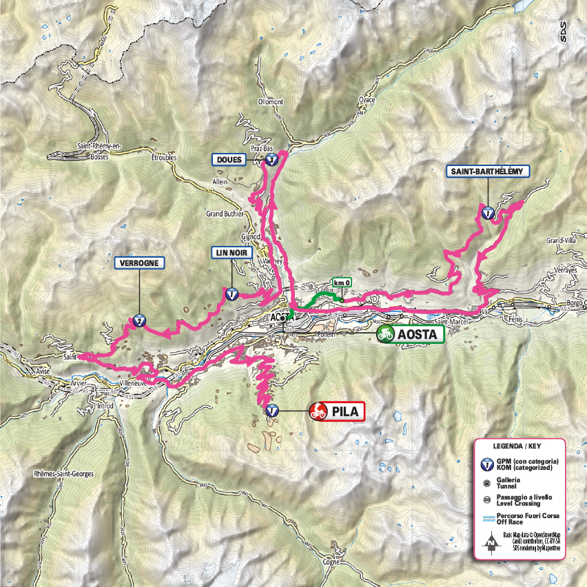
Aosta – Pila
profile
map
technical info
Brutal stage with over 4,000 m of climbing. Riders traverse Aosta’s “balconies” and cover Saint-Barthélémy, Douas, Lin Noir, Verrogne, and Pila, climbed for the first time from the Gressan side (normally tackled downhill).
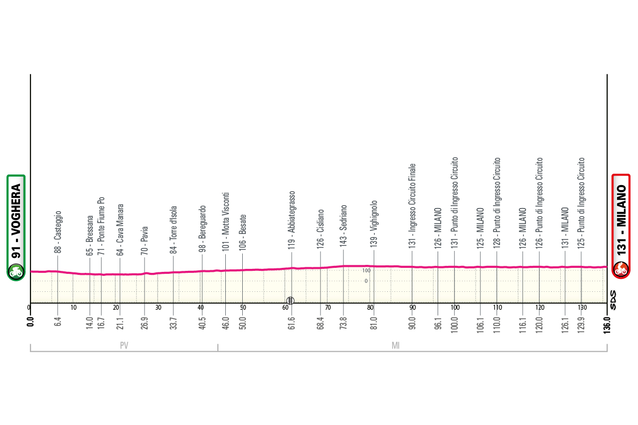
Voghera – Milano
profile
map
technical info
Completely flat stage featuring a final city circuit. Bunch sprint guaranteed.
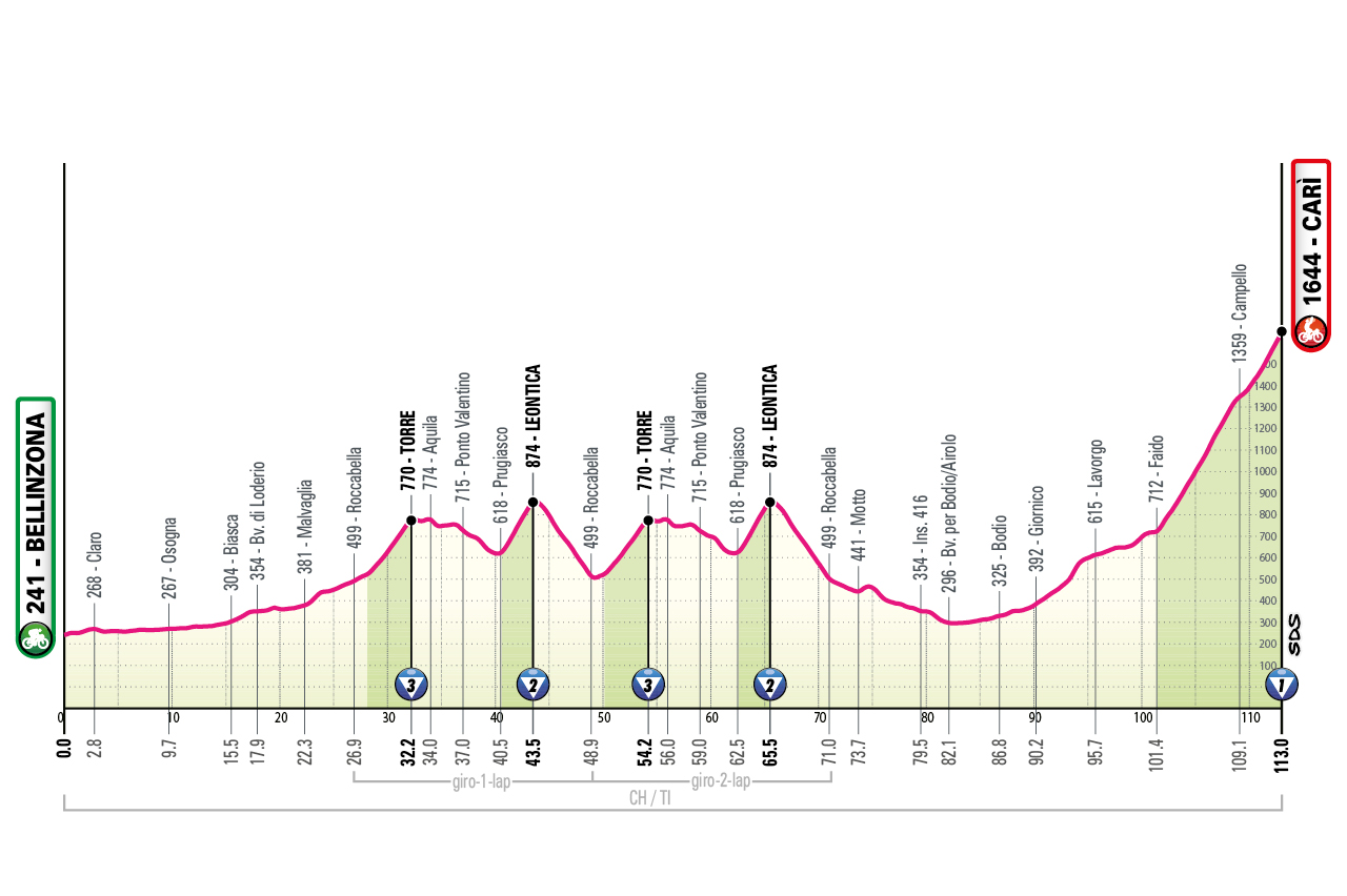
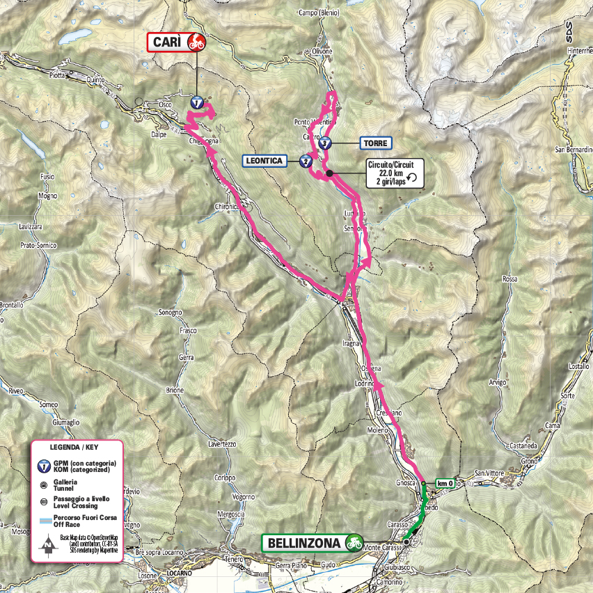
Bellinzona – Carì
profile
map
technical info
Very short but high-altitude stage. Early circuit with two demanding climbs (Torre, Leontica) before a straight uphill finish in Carì.
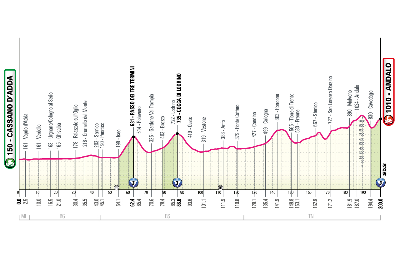
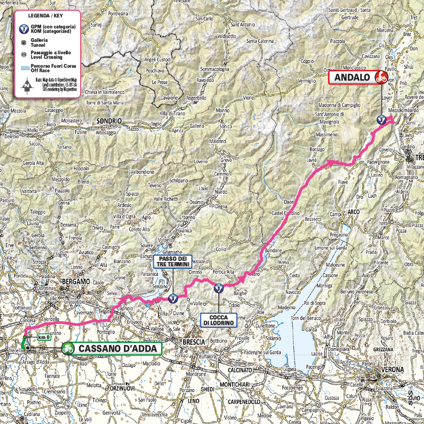
Cassano d'Adda – Andalo
profile
map
technical info
Initially flat, then a sequence of short climbs to the finish. Short, partially closed loop near the end.
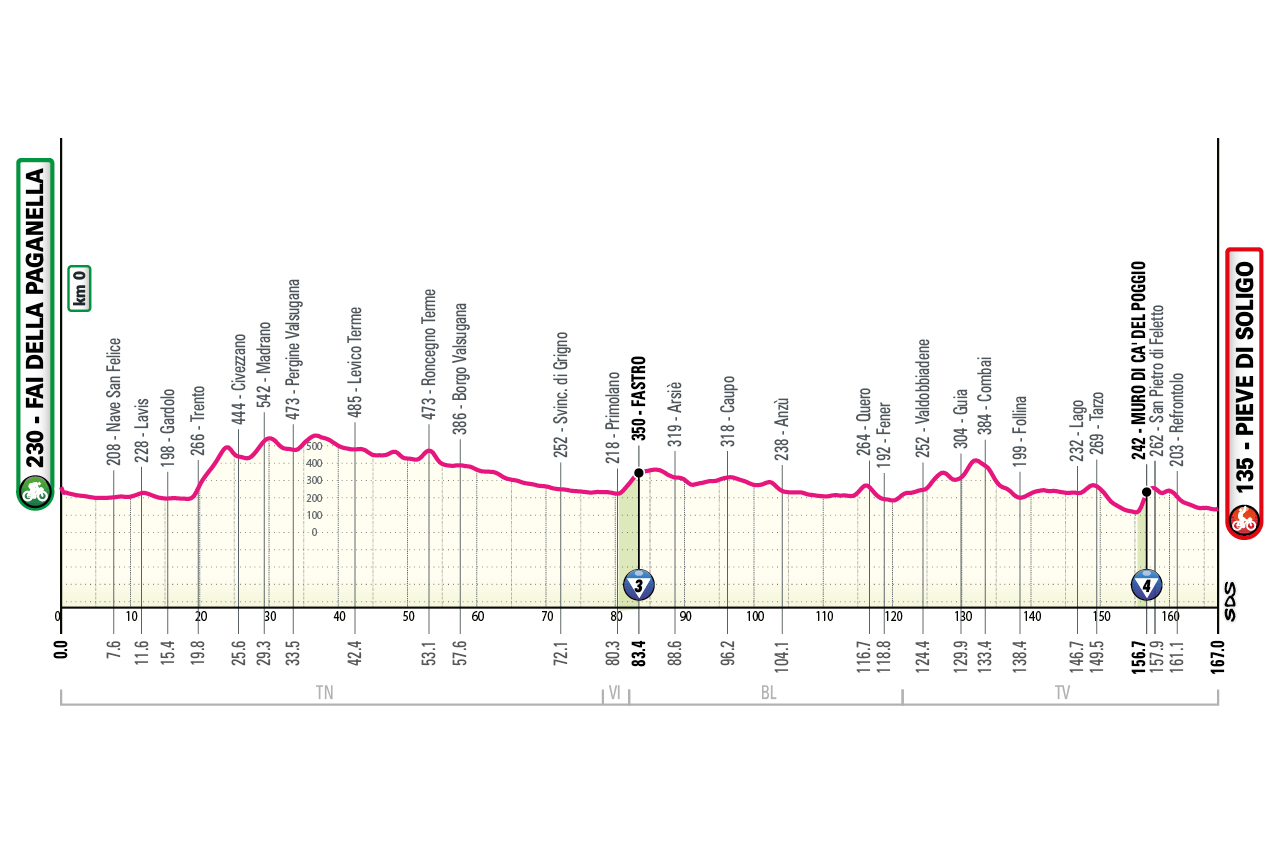
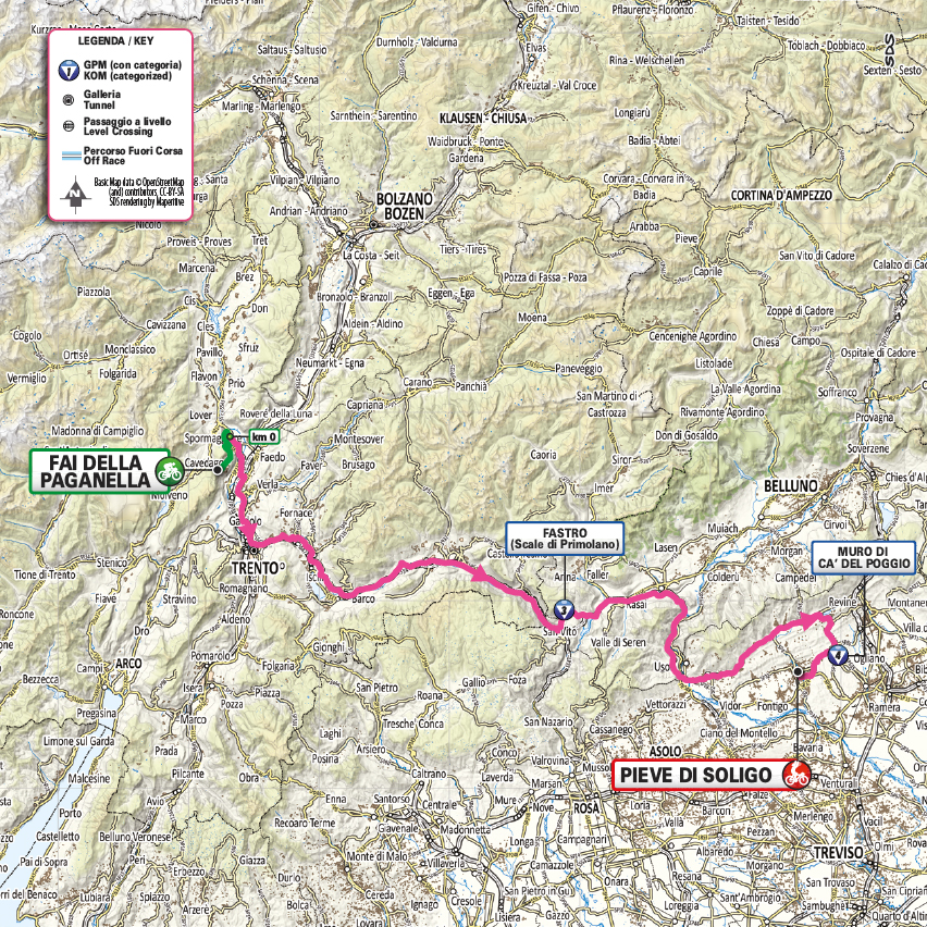
Fai della Paganella – Pieve di Soligo
profile
map
technical info
Gently undulating stage with continuous rollers. Neutral descent to km 0, then relentless ups and downs. At 9 km to go, the famous Muro di Ca’ del Poggio may be the key factor between a sprint and a selective finish.
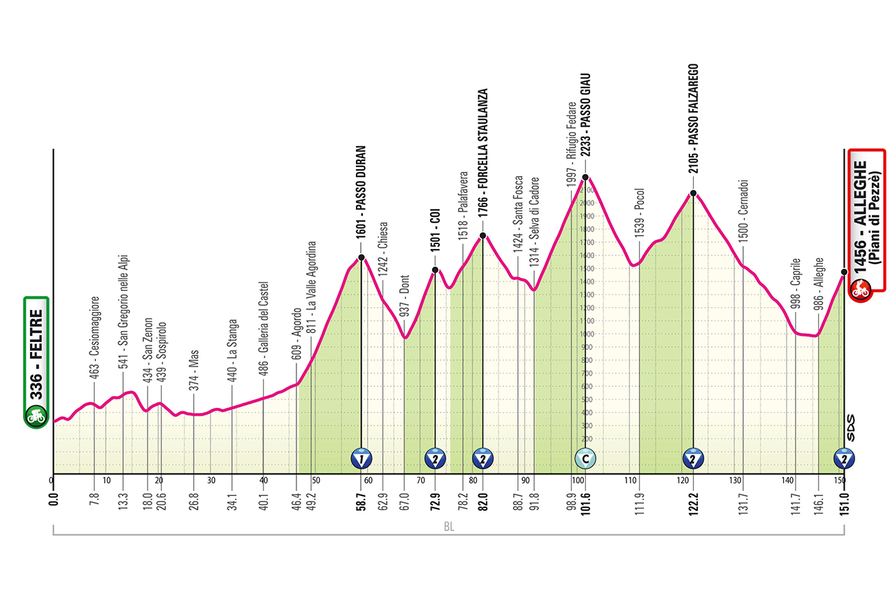
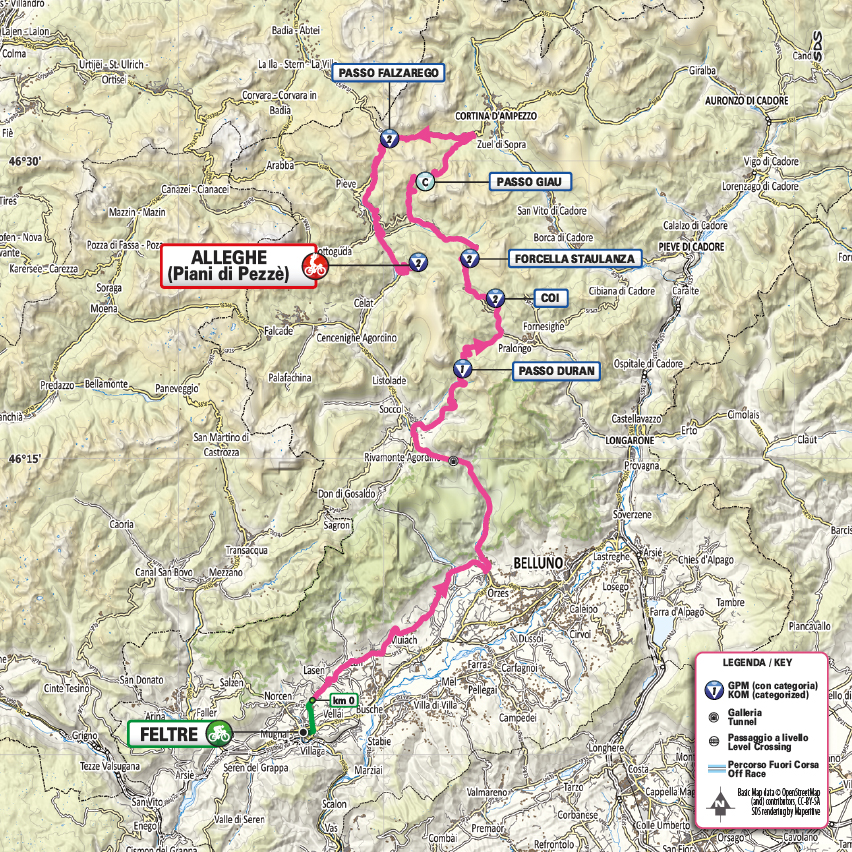
Feltre – Alleghe (Piani di Pezzè)
profile
map
technical info
Classic Dolomite tappone in climbing style but modern in length: 151 km with 5,000 m of elevation. Riders face Passo Duran, Passo Staulanza (via the steep Coi variant, up to 19%), Passo Giau from its hardest side (Cima Coppi, 2236 m), Passo Falzarego, then the final short climb (5 km at ~10%, peaks 15%).
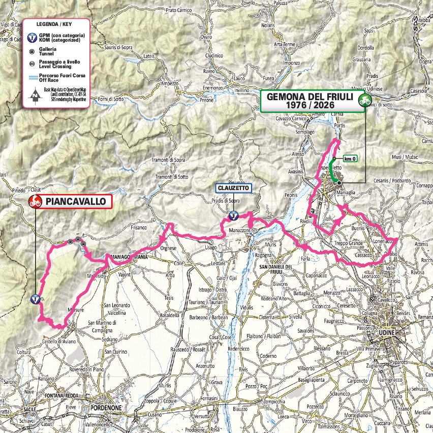
Gemona del Friuli 1976-2026 – Piancavallo
profile
map
technical info
Rolling early terrain, then a double ascent of Piancavallo. The route crosses the epicentre of the 1976 Friuli earthquake (990 victims, tens of thousands displaced) before climbing Piancavallo twice, with a loop including Lago di Barcis. Pantani won here in 1998 before taking the Giro overall.
Roma – Roma
profile
map
technical info
Final parade stage, essentially identical to recent years: an opening out-and-back run to Ostia, followed by several laps of the city-centre circuit.